
GeoSphere Austria · sources
Elevation profile
Snow depth
Model · 1 kmLoading snow model …
- Distance
- 12.7 km
- Ascent
- 950 m
- Descent from source
- 950 m
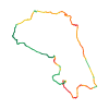
Ski tour · Alpes-de-Haute-Provence. The published line is 12.7 km long.
Map layers
Take the route with you
Download GPX ↓Original route geometry with estimated elevations from our terrain model. No account or app required.
ODbL 1.0 + CC BY-SA 3.0 FR · Licence. Source credits are included in the file.
- Highest point
- ≈ 2,826 m
Source directions
Aufstieg: Von der Maljasset-Hütte die Ubaye (1902m) traversieren, dann den Langlaufloipen folgen, die zum kleinen Mary-Tals führen. Den Wildbach (Brücke) überqueren und weiter über das Feld bis zu einem zweiten kleinen Tal (Straße). Diese Straße, die in einem flachen Gebiet (2045m) endet, hinaufsteigen. Das kleine Mary-Tal entlang dieser Seite bis zu den Schaffarmen ganz oben hinaufsteigen (2380m -Unterstand geöffnet). Auf die linke Seite des kleinen Tals gelangen und unter den Felsen von Marinet in Richtung des Überlaufes der Marinet-Seen traversieren (am Fuß der Aiguille Large). Kurz vor dem See nach rechts über eine Mulde bis zur Straße nördlich von Chilliol aufsteigen. Die breite Bergspitze mit Skiern oder zu Fuß je nach Schneelage über die SW-Wand erklimmen.
Abfahrt: Vom Gipfel zum Pass gelangen, dann unter dem Large-Pass über eine hübsche Mulde, die zum Fuß der Bergspitze Pierre André führt, abfahren. Unter der Bergspitze traversieren, indem man ganz oben bleibt. Man fäht folglich unterhalb der N-Wand, um am Fuß des Miéjour-Passes auf 2658m anzukommen, den man hinaufsteigt (60m machbar, ohne Felle anzulegen). Danach im kleinen Teste-Tal und dann im Lärchenwald abfahren. Man gelangt zur Barge-Siedlung, 1 km flussabwärts von Maljasset, das man über die Langlaufloipen erreicht.
Variante: Eine Abstiegsvariante besteht darin, über das kleine Chilliol-Tal abzufahren (PD+, S3). Man kommt dann 3km flussabwärts von Barge auf der Straße von Maljasset an.
Source safety information
Leichte Hänge für den Aufstieg, anspruchsvoll für die Abfahrt.
Hauptsächlich im Lärchenwald, wo die Hangneigung teilweise 30-35°.
N dann SO-Aufstieg. Erste Abfahrt NO. Zweite Abfahrt NW.
Zugang:
Barcelonnette, Jaussiers, St-Paul über die D990, dann die D25 bis nach Maljasset; die Straße von Maljasset ist immer offen (manchmal einige Tage nach einem starken Schneefall gesperrt). Man kann ebenfalls über die Straße des Vars-Passes auch von Guillestre zum Startpunkt gelangen (D902).
Unterkunft:
Maljasset-Hütte 1902m, 60 Plätze. Tel.: 04 92 84 34 04. Das ganze Jahr bewartet. Wärter: Philippe Lantelme.
Source directions
Climb: From the Maljasset refuge, traverse the Ubaye (point 1902m) then follow the cross-country ski tracks which lead to the opening of Vallon de Mary. Traverse the torrent (bridge) and continue in the field until a second small dale (road). Go up this road which ends on a flat area (point 2045m). Then go up the Vallon de Mary by skirting this side until the higher Bergeries de Mary (2380m -abri open). Go back to the left bank of the dale and traverse under the Marinet rocks in the direction of the spillway of the Lacs du Marinet (at the foot of Aiguille Large). Slightly before the lake go up on the right via a scoop until the N Pas of Chilliol. Climb the broad pinnacle on skis or on foot depending on the snow cover via the SW face.
Descent: From the summit you reach the pass then descend under the Large pass via a pretty scoop which leads to the foot of Pierre André pinnacle. Traverse under the pinnacle while remaining as high as possible. You then pass under the N face to arrive at the foot of Col de Miéjour 2658m go up it (60m, feasible without putting skins back on). Then descend the Teste dale and the larch forest. You arrive at the hamlet of the Barge 1 km downhill from Maljasset that is reached via the cross-country ski tracks.
Variant: a descent variant involves descending by the Chilliol dale (PD +, S3). You arrive 3km downhill from the Barge on the Maljasset road.
Source safety information
Gentle slopes for the climb, unrelenting for the descent.
Mainly in the larch forest where the slope reaches 30-35° in certain places.
Climb N then SE. First descent NE. Second descent NW.
Access:
Barcelonnette, Jaussiers, St-Paul via D990 then take D25 until Maljasset, Route de Maljasset is always open (sometimes closed a few days after a major snowfall) You can also take the Col de Vars road (D902) after Guillestre.
Accommodation:
Maljasset refuge 1902m, 60 places tel: 04 92 84 34 04. Attended all year. Caretaker: Philippe Lantelme.
Source directions
Salita: Dal rifugio di Maljasset, traversare l'Ubaye (punto 1902m) e seguire poi le piste di fondo che conducono fino al Vallone di Mary. Traversare il torrente (ponte) e continuare nel campo fino ad un secondo piccolo vallone (strada). Risalire questa strada che giunge ad un ripiano (punto 2045m). Risalire allora il Vallone di Mary costeggiando questo lato fino alle Bergeries de Mary supérieure (2380m - riparo aperto). Passare nuovamente sulla sponda sinistra del vallone e traversare sotto le rocce di Marinet in direzione del bacino dei laghi di Marinet (ai piedi dell'Aiguille Large). Poco prima del lago alzarsi sulla destra attraverso una conca fino al Pas N de Chilliol. Scalare l'aiguille large con gli sci o anche a piedi a seconda dell'innevamento dalla parete SW.
Discesa: Dalla vetta raggiungere la sella e scendere poi sotto il col Large da una bella conca che conduce ai piedi della guglia Pierre André. Traversare sotto la guglia restando il più in alto possibile. Si passa allora sotto la parete N per arrivare ai piedi del Col de Miéjour 2658m che bisogna risalire (60m, fattibile anche senza rimettere le pelli di foca). Scendere il vallone di Teste poi nella foresta di larici. Si arriva al piccolo villaggio della Barge ad 1 km a valle di Maljasset raggiungibile dalle piste di fondo.
Variante: una variante di discesa consiste nello scendere dal vallone di Chilliol (PD+, S3). Si arriva quindi 3km a valle della Barge sulla strada di Maljasset.
Source safety information
Pendii dolci in salita, sostenuti in discesa.
Soprattutto nella foresta di larici in cui la pendenza raggiunge in alcuni punti 30-35°.
Salita N poi SE. Prima Discesa NE. Seconda discesa NW.
Accesso :
Barcelonnette, Jaussiers, St-Paul dalla D990 prendere poi la D25 fino a Maljasset Route de Maljasset sempre aperta (a volte può rimanere chiusa per alcuni giorni dopo una forte nevicata) si può accedere anche dalla strada del Col de Vars (D902) o da Guillestre.
Alloggio :
Rifugio di Maljasset 1902m, 60 posti. Tel: 04 92 84 34 04. Custodito tutto l'anno. Custode: Philippe Lantelme.
Source summary
Un must de l'Ubaye, magnifique parcours pour une dénivelée si faible.
Source directions
## Montée
[img=1286346 right]Montée au Pas de Chillol[/img]
Depuis Maljasset, suivre les pistes de fond qui mènent jusqu'au débouchoir du vallon de Mary. Traverser le torrent (pont) et continuer dans le champ jusqu'à un deuxième petit vallon (route). Remonter cette route qui aboutit sur un replat à 2045 m. Remonter alors le vallon de Mary en longeant ce flanc jusqu'aux Bergeries supérieures de Mary (2380 m - abri ouvert). Repasser sur la rive gauche du vallon et traverser sous les roches de Marinet en direction du déversoir des lacs de Marinet (au pied de l'Aiguille Large). Un peu avant le lac s'élever sur la droite par une combe jusqu'au Pas N de Chillol. En option, gravir l'Aiguille Large par la face SW, à ski ou à pied selon l'enneigement.
## Descente
[img=1286347 right]Aiguille Pierre André[/img]
Du sommet, rejoindre le Col Large puis descendre côté NW par une jolie combe qui mène au pied de l'Aiguille Pierre André. Traverser à flanc de coteau sous l'aiguille en restant au plus haut. Passer alors sous la face N pour arriver au pied du Col de Miéjour, le remonter (60 m). Il est aussi possible de remonter à gauche de l'Aiguille Pierre André (S, en général à pied) et de rejoindre le col de Miéjour par le couloir des Militaires (4.1).
Descendre ensuite le vallon de Teste puis dans la forêt de mélèzes. Arriver au hameau de la Barge, 1 km en aval de Maljasset rejoint par les pistes de fond.
### Variante de descente
Une variante de descente consiste à descendre par le vallon de Chilliol (PD+, S3). Arrivée à 3 km en aval de la Barge sur la route de Maljasset.
Source safety information
- Pentes douces pour la montée, soutenues pour la descente.
- Orientation : Montée N puis SE. Première Descente NE. Seconde descente NW.
- Attention aux plaques sur les deux versants du Col de Miéjour, et aux coulées dans les pentes dominant la vallée de Maljasset.
The map shows the published line. Provider ascent and descent retain their original meaning; estimates along the line are marked ≈. An additional return route is not automatically included in the line. Elevation profile estimated from Copernicus DEM. Provider statistics may differ.
Weather · next 48 hours
Loading weather …
BULLETIN
Avalanche bulletins along this route
No EUREGIO bulletin region is assigned to this line.
Check the official report for current danger and validity. Avalanche warning services
Regional avalanche bulletins do not assess an individual route. Check validity, elevation and aspect.
NATUR · NATURE
Protected areas along the route
No protected area was found along this line in the available dataset. Follow local notices.
Open on your iPhone · QR
Source & data
Camptocamp · Camptocamp-Association, Marc Fournier, Christian, Matt82, Bruno Besson, L. Besson, rabot, botopo · https://www.camptocamp.org/routes/48480 · Coordinates reprojected; DEM elevation estimates · ODbL 1.0 + CC BY-SA 3.0 FR
Camptocamp · 2022-09-07T20:35:22.935623+00:00
Produced using Copernicus WorldDEM-30 © DLR e.V. 2010-2014 and © Airbus Defence and Space GmbH 2014-2018 provided under COPERNICUS by the European Union and ESA; all rights reserved.
Tour-ID: c2c:route/48480 · Revision: 3e2e978e07d1