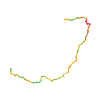
Surface from sourceAsphalt · Gravel · Other surface · Path
Distance from source16.4 km
Lowest elevation from source799 m
Highest elevation from source1,652 m
Notices in the source snapshot
These notices come from the stored source snapshot. They do not establish a current closure. Check the source website for current information.
Bad Mitterndorf: Straßensperre im Ortszentrum
Aufgrund von Fräsarbeiten muss im Bereich NKD Bad Mitterndorf bis Schupfer´s Dorfschmiede die komplette Straße gesperrt werden.
Begins according to source2026-09-29
Ends according to source2026-09-29
Diversion from source
Eine Umleitung ist großräumig über Grimminghalle, Spar Markt Bad Mitterndorf und Neuhofen möglich.
The map shows the published line. Provider ascent and descent retain their original meaning; estimates along the line are marked ≈. An additional return route is not automatically included in the line. Elevation profile estimated from Copernicus DEM. Provider statistics may differ.
Weather · next 48 hours
Loading weather …
BULLETIN
Avalanche bulletins along this route
No EUREGIO bulletin region is assigned to this line.