
Ski tours · Département Ain
Crozet - les Deux Potes · Depuis l'atterrissage de Crozet
Elevation profile
- Distance
- 4.6 km
- Ascent
- 960 m
- Descent from source
- 960 m
Ski tour · Département Ain. The published line is 4.6 km long.
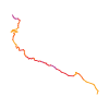
Map layers
- Highest point
- ≈ 1,495 m
Source summary
Itinéraire permettant de monter à pied au décollage des deux potes.
Source directions
De l'atterrissage, gagner le parking du télécabine du Fierney.
Remonter sous le télécabine par le sentier direct jusqu'au restaurant "Le yéti" et la gare amont.
Ensuite, traverser le téléski à droite et poursuivre par la piste jusqu'au chalet de Fierney- Giraud.
Prendre un sentier discret qui remonte jusqu'au décollage.
Source safety information
Si le télécabine est ouvert, il permet de raccourcir la montée.
The map shows the published line. Provider ascent and descent retain their original meaning; estimates along the line are marked ≈. An additional return route is not automatically included in the line. Elevation profile estimated from Copernicus DEM. Provider statistics may differ.
BULLETIN
Avalanche bulletins along this route
No EUREGIO bulletin region is assigned to this line.
Check the official report for current danger and validity. Avalanche warning services
Regional avalanche bulletins do not assess an individual route. Check validity, elevation and aspect.
NATUR · NATURE
Protected areas along the route
Haute Chaîne Du Jura
Réserve naturelle nationale
Kartendarstellung vereinfacht; maßgeblich ist die verlinkte Originalquelle.
Haut-Jura
Parc naturel régional
Kartendarstellung vereinfacht; maßgeblich ist die verlinkte Originalquelle.
Open on your iPhone · QR
Source & data
Camptocamp · Matt82, CaBot · https://www.camptocamp.org/routes/1833829 · Coordinates reprojected; DEM elevation estimates · ODbL 1.0 + CC BY-SA 3.0 FR
Camptocamp · 2025-11-13T14:23:56.955114+00:00
Produced using Copernicus WorldDEM-30 © DLR e.V. 2010-2014 and © Airbus Defence and Space GmbH 2014-2018 provided under COPERNICUS by the European Union and ESA; all rights reserved.
Tour-ID: c2c:route/1833829 · Revision: 609ab60a17d3