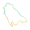
Original route geometry with estimated elevations from our terrain model. No account or app required.
CC BY 4.0 · Licence. Source credits are included in the file.
Highest point
≈ 691 m
Duration from source
1 h 35 min
Source difficultyL ÖW
Season from source
Mar, Apr, May, Jun, Jul, Aug, Sep, Oct, NovJanFebMarAprMayJunJulAugSepOctNovDec
↗ Refreshments indicated by source
Start from sourceCafé-Restaurant Take away Kiener in St. Georgen im Attergau, 4880 St. Georgen im Attergau
Finish from sourceCafé-Restaurant Take away Kiener in St. Georgen im Attergau, 4880 St. Georgen im Attergau
Route shape from sourceLoop
Hints from sourceChildren · Couples · Families · Friends · Groups · Lodging · Outdoor play area · Parking · School groups · Themed trail · Wheelchair access · With children
These notices come from the stored source snapshot. They do not establish a current closure. Check the source website for current information.
Information nur teilweise begehbar
Liebe Besucher,
Aufgrund von Bauarbeiten ist der Keltenbaumweg nicht durchgehend begehbar:
Aufgrund einer defekten Brücke ist der Spielplatz einschließlich des darunterliegenden Seilzugs gesperrt.
Beim Keltenhaus ist eine Umleitung eingerichtet.
Begins according to source2026-09-24
Ends according to source2026-10-06
The map shows the published line. Provider ascent and descent retain their original meaning; estimates along the line are marked ≈. An additional return route is not automatically included in the line. Elevation profile estimated from Copernicus DEM. Provider statistics may differ.
Weather · next 48 hours
Loading weather …
BULLETIN
Avalanche bulletins along this route
No EUREGIO bulletin region is assigned to this line.