
← Back to the map

Hiking · Steiermark

Spielfelder Weingärten – Natur – Archäologieweg

Elevation profile

Explore the elevation profile
2603845080 km13.2 kmm
Distance
13.1 km
Ascent
460 m
Descent from source
460 m

Hike · Steiermark. The published line is 13.1 km long.
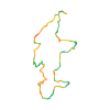
Route outline
Route outline without a basemap
Map layers

Take the route with you

Download GPX ↓

Original route geometry with estimated elevations from our terrain model. No account or app required.

CC BY 4.0 · Licence. Source credits are included in the file.

Highest point
≈ 508 m
Duration from source
4 h 30 min
Source difficulty—
Season from source
Mar, Apr, May, Jun, Jul, Aug, Sep
Start from sourceSpielfeld - Bahnhof, Südbahnstraße 7, 8472 Spielfeld
Finish from sourceSpielfeld - Bahnhof, Südbahnstraße 7, 8472 Spielfeld
Seasons from sourceAutumn · Spring · Summer
Website from sourceOpen website ↗
Distance from source13.1 km
Highest elevation from source509 m

The map shows the published line. Provider ascent and descent retain their original meaning; estimates along the line are marked ≈. An additional return route is not automatically included in the line. Elevation profile estimated from Copernicus DEM. Provider statistics may differ.

Weather · next 48 hours

Loading weather …

BULLETIN

Avalanche bulletins along this route

No EUREGIO bulletin region is assigned to this line.

Check the official report for current danger and validity. Avalanche warning services

Regional avalanche bulletins do not assess an individual route. Check validity, elevation and aspect.

NATUR · NATURE

Protected areas along the route

Südweststeirisches Weinland

Landschaftsschutzgebiet

European Environment Agency (EEA) · CC BY 4.0

Kartendarstellung vereinfacht; maßgeblich ist die verlinkte Originalquelle.

Südsteiermark

Naturpark

European Environment Agency (EEA) · CC BY 4.0

Kartendarstellung vereinfacht; maßgeblich ist die verlinkte Originalquelle.

2 Damen stehen vor der Platschbergwarte mit klarem Himmel.
WEGES · CC-BY · Original
Eine Dame mit orangem Wanderrucksack steht auf der Platschbergwarte und genießt die Aussicht. Im Hintergrund sieht man die Weingegend bei schönem Wetter mit blauem Himmel.
WEGES · CC-BY · Original
Herrlich grüner Weingarten, im Hintergrund satte grüne Wälder und Weinberge. Eine Dame mit orangem Wanderrucksack steht vor einem grünen Weingarten.
WEGES · CC-BY · Original
Eine Dame geht einen idyllischen Aspahltweg entlang - rundherum viele grüne Sträucher und Bäume. Im Hintergrund sieht man blauen Himmel und ein rotes Dach eines Gebäudes.
WEGES · CC-BY · Original
Buschenschank Jause am Tisch, mit einem Glas Wein, im Hintergrund sieht man viele grüne Bäume und Sträucher und einen blauen Himmel.
WEGES · CC-BY · Original
Grüne Weinberge mit Häusern, grüne Wälder, typische Pappeln und ein bewölkter Himmel.
WEGES · CC-BY · Original

IPHONE · ANDROID · WATCH

Maps and recording on your phone and watch.

Take your route offline. For iPhone, Android, Apple Watch and Wear OS.

Open in Hanglage ↗
Source & data

Data sources & safety

CC-BY-4.0: Österreich Werbung · CC BY 4.0

Österreich Werbung · 2026-06-11T10:15:58+02:00

Produced using Copernicus WorldDEM-30 © DLR e.V. 2010-2014 and © Airbus Defence and Space GmbH 2014-2018 provided under COPERNICUS by the European Union and ESA; all rights reserved.

Tour-ID: oew:contwise_tour_121349508 · Revision: bff6441630a7