Skip to content
HanglageObernbergtal / Field guide

Lake Obernberg & Waldesruh · Kastnerbergalm & Waldbauer · Fradertal & Vinaders

Ski touring
in the Obernberg Valley.

Farm meadows, sparse larch woodland and the mountains around Lake Obernberg give the routes different characters. Alpine pastures lead to broad ridges, hollows and steeper summit slopes. The approach matters from the outset: Waldesruh, Kastnerbergalm, Fradertal and the meadows near Vinaders open onto different sides of the mountains.

A regional guide by Hanglage · 9 selected routes
Researched 3 November 2026 · Not a current conditions assessment

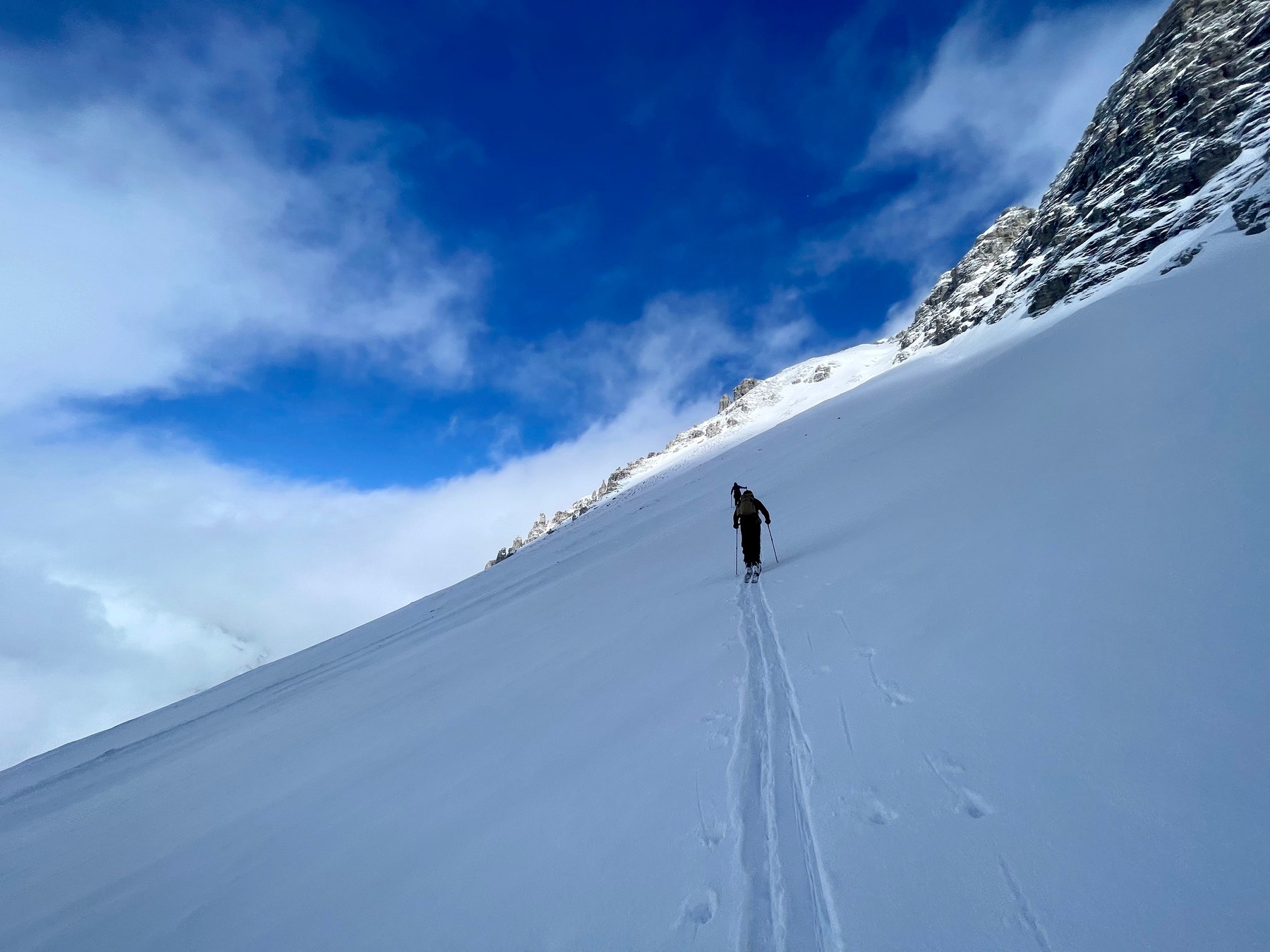
An uphill ski track crosses an open snow slope in the Obernberg Valley. Archive photograph from February 2023.
OBERNBERGTAL / ARCHIVE2023-02-25 · Bernhard Hering
09 routesMap · Elevation profile · GPXBefore you go ↗

Before you go

Avalanche bulletin for your touring area

Read the official original for affected elevations, aspects and validity. A missing bulletin does not mean low danger.

01 / Orientation

Explore the route map

Choose an area to frame the map, or select a route name to highlight its line.

HANG LAGE / OBERNBERGTAL

Loading the topographic map.

Routes and GPX downloads are available below.
↑ NColours show grade along the line, not difficulty or safety.

OpenStreetMap / Protomaps · Copernicus DEM · Routes retain individual sources and licences. Data sources & safety ↗

Terrain & approaches

How the areas differ

01 / LAKE OBERNBERG & WALDESRUH

Lake Obernberg & Waldesruh

The ascents branch out above Waldesruh. Woodland and clearings lead towards Allerleigrubenspitze and its broad upper ridge. Grubenkopf and Hoher Lorenzen lie beyond Lake Obernberg, with separate hollows, cols and summit approaches above the lake.

3 routes ↓Area sources: Source 1 · Source 2
02 / KASTNERBERGALM & WALDBAUER

Kastnerbergalm & Waldbauer

Forest tracks and woodland shape the lower approaches towards Kastnerbergalm before the slopes open out. Trunajoch is a col destination, while Rötenspitze and Muttenkopf continue into summit terrain. The selected routes start at either Waldbauer or Waldesruh, so their valley approaches are part of different ascents.

3 routes ↓Area sources: Source 1 · Source 2
03 / FRADERTAL & VINADERS

Fradertal & Vinaders

Fradersteller follows the Fraderbach side valley towards the border ridge. Leitnerberg and Eggerberg start farther down the main valley near Vinaders. Farms, open meadows and sparse larch woodland shape their lower approaches before the routes reach open upper slopes.

3 routes ↓Area sources: Source 1 · Source 2

02 / Route portraits

9 routes by area

3 routes

Lake Obernberg & Waldesruh

Area on the map ↑
01N ↑Route outline · no map scale

Lake Obernberg & Waldesruh · Ski route from source

Allerleigrubenspitze ab Waldesruh

Allerleigrubenspitze (2.131m)

Woodland clearings give way to a broad ridge that becomes gentler higher up.

Start: Parkplatz Waldesruh am Ortsende, Gereit 60, 6157 Obernberg/Brenner

Finish: Gipfel Allerleigrubenspitze, Österreich, Obernberg am Brenner

Route report & area information ↗

Mapped distance
5.2 km
Ascent from source
700 m
Time from source
2 h 00 min
Start, finish, difficulty & source

Source difficulty: not supplied

Allerleigrubenspitze (2.131m)
CC-BY-4.0: Österreich Werbung · CC BY 4.0

02N ↑Route outline · no map scale

Lake Obernberg & Waldesruh · Ski route from source

Grubenkopf ab Waldesruh

Grubenkopf (2.339 m)

The ascent passes Lake Obernberg and crosses hollows towards Grubenjoch, followed by the summit ridge.

Start: Parkplatz Waldesruh am Ortsende, Gereit 60, 6157 Obernberg/Brenner

Finish: Gipfel Grubenkopf, Italien, Obernberg am Brenner

Route report & area information ↗

Mapped distance
5.7 km
Ascent from source
885 m
Time from source
3 h 00 min
Start, finish, difficulty & source

Source difficulty: not supplied

Grubenkopf (2.339 m)
CC-BY-4.0: Österreich Werbung · CC BY 4.0

03N ↑Route outline · no map scale

Lake Obernberg & Waldesruh · Ski route from source

Hoher Lorenzen ab Waldesruh

Hoher Lorenzen · Waldesruh

This approach begins at the head of the valley. The Fradertal variant is a different ascent.

Start: Waldesruh

Finish: Hoher Lorenzen

Route report & area information ↗

Mapped distance
5.3 km
Ascent, estimated
≈ 886 m
Time from source
—
Start, finish, difficulty & source

Source difficulty: not supplied

Hoher Lorenzen · Waldesruh
© ÖAV, DAV, AVS – Ski Touring Routes for Austria, Germany and South Tyrol, CC BY-ND 4.0 · CC BY-ND 4.0

3 routes

Kastnerbergalm & Waldbauer

Area on the map ↑
04N ↑Route outline · no map scale

Kastnerbergalm & Waldbauer · Ski route from source

Muttenkopf ab Waldesruh

Muttenkopf (2.638 m)

Above the pastures, the route climbs towards Muttenjoch and then a steeper upper summit slope.

Start: Parkplatz Waldesruh/Ortsende, Gereit 60, 6157 Obernberg/Brenner

Finish: Gipfel Muttenkopf, Österreich, Trins

Route report & area information ↗

Mapped distance
6.5 km
Ascent from source
1,200 m
Time from source
4 h 00 min
Start, finish, difficulty & source

Source difficulty: not supplied

Muttenkopf (2.638 m)
CC-BY-4.0: Österreich Werbung · CC BY 4.0

05N ↑Route outline · no map scale

Kastnerbergalm & Waldbauer · Ski route from source

Rötenspitze ab Waldbauer

Rötenspitze · Obernberg-Waldbauer

This route includes the valley approach from Waldbauer. Starting at the Obernberg Alpine Club house would be a different variant.

Start: Obernberg-Waldbauer

Finish: Rötenspitze

Route report & area information ↗

Mapped distance
5.0 km
Ascent, estimated
≈ 1,047 m
Time from source
—
Start, finish, difficulty & source

Source difficulty: not supplied

Rötenspitze · Obernberg-Waldbauer
© ÖAV, DAV, AVS – Ski Touring Routes for Austria, Germany and South Tyrol, CC BY-ND 4.0 · CC BY-ND 4.0

06N ↑Route outline · no map scale

Kastnerbergalm & Waldbauer · Ski route from source

Trunajoch ab Waldbauer

Trunajoch · Obernberg-Waldbauer

The col is the destination. Continuing to Rötenspitze is not part of this route.

Start: Obernberg-Waldbauer

Finish: Trunajoch

Route report & area information ↗

Mapped distance
4.5 km
Ascent, estimated
≈ 725 m
Time from source
—
Start, finish, difficulty & source

Source difficulty: not supplied

Trunajoch · Obernberg-Waldbauer
© ÖAV, DAV, AVS – Ski Touring Routes for Austria, Germany and South Tyrol, CC BY-ND 4.0 · CC BY-ND 4.0

3 routes

Fradertal & Vinaders

Area on the map ↑
07N ↑Route outline · no map scale

Fradertal & Vinaders · Ski route from source

Fradersteller ab Obernberg

Fradersteller · Obernberg am Brenner

Alpine pastures and upper hollows lead through Fradertal towards the border ridge.

Start: Obernberg am Brenner

Finish: Fradersteller

Route report & area information ↗

Mapped distance
4.1 km
Ascent, estimated
≈ 878 m
Time from source
—
Start, finish, difficulty & source

Source difficulty: not supplied

Fradersteller · Obernberg am Brenner
© ÖAV, DAV, AVS – Ski Touring Routes for Austria, Germany and South Tyrol, CC BY-ND 4.0 · CC BY-ND 4.0

08N ↑Route outline · no map scale

Fradertal & Vinaders · Ski route from source

Leitnerberg ab Vinaders/Moserhof

Leitnerberg (2.309 m)

Meadows and larch woodland shape the lower ascent before the terrain opens towards the summit.

Start: Parkplatz Vinaders Nähe Moserhof, Vinaders 353, 6156 Gries/Brenner

Finish: Leitnerberg, Österreich, Obernberg am Brenner

Route report & area information ↗

Mapped distance
4.2 km
Ascent from source
1,030 m
Time from source
3 h 00 min
Start, finish, difficulty & source

Source difficulty: not supplied

Leitnerberg (2.309 m)
CC-BY-4.0: Österreich Werbung · CC BY 4.0

09N ↑Route outline · no map scale

Fradertal & Vinaders · Ski route from source

Eggerberg ab Vinaders

Eggerberg über Vinaders (2.280 m)

The ascent starts at the church in Vinaders, not at the head of the Obernberg Valley.

Start: Parkplätze Vinaders Kirche, Vinaders 344, 6156 Gries/Brenner

Finish: Eggerberg (2.280 m), Österreich, Gries am Brenner

Route report & area information ↗

Mapped distance
4.8 km
Ascent from source
1,011 m
Time from source
3 h 00 min
Start, finish, difficulty & source

Source difficulty: not supplied

Eggerberg über Vinaders (2.280 m)
CC-BY-4.0: Österreich Werbung · CC BY 4.0

03 / Side by side

Compare distance and ascent

Distances describe the mapped course. Additional return journeys and descents may be missing. Check snow, weather and avalanche conditions separately. ≈ marks ascent estimated from the elevation model. — means no time supplied. Different difficulty scales are not converted.

Route & areaDistanceAscentTime from source
01Allerleigrubenspitze ab WaldesruhSki route from source · Lake Obernberg & Waldesruh5.2 km700 mSource2 h 00 min
02Grubenkopf ab WaldesruhSki route from source · Lake Obernberg & Waldesruh5.7 km885 mSource3 h 00 min
03Hoher Lorenzen ab WaldesruhSki route from source · Lake Obernberg & Waldesruh5.3 km≈ 886 mElevation model—
04Muttenkopf ab WaldesruhSki route from source · Kastnerbergalm & Waldbauer6.5 km1,200 mSource4 h 00 min
05Rötenspitze ab WaldbauerSki route from source · Kastnerbergalm & Waldbauer5.0 km≈ 1,047 mElevation model—
06Trunajoch ab WaldbauerSki route from source · Kastnerbergalm & Waldbauer4.5 km≈ 725 mElevation model—
07Fradersteller ab ObernbergSki route from source · Fradertal & Vinaders4.1 km≈ 878 mElevation model—
08Leitnerberg ab Vinaders/MoserhofSki route from source · Fradertal & Vinaders4.2 km1,030 mSource3 h 00 min
09Eggerberg ab VinadersSki route from source · Fradertal & Vinaders4.8 km1,011 mSource3 h 00 min

04 / Before you go

What to check
before setting out

01

Weather, snow and avalanche conditions

Read the official avalanche bulletin. Check validity, elevation and aspect. A route-line colour shows grade, not safety.

Find the official bulletin ↗
02

Course and return journey

Check the original start, finish and direction. A line may show only an ascent or a connection. Plan the return journey, last connection and any lifts separately.

See the original routes ↗
03

Path, weather and local rules

Check current conditions and local information. Observe closures, wildlife rules and operating hours. A mapped path establishes neither current access nor a particular surface quality.

Regional information ↗
This overview is for orientation, not navigation or a declaration of safety. Independent planning, appropriate equipment and on-site assessment remain essential.

HANG LAGE

Route maps and recording
on your phone and watch.

Download your map and route before setting off. In Hanglage, you can use them without a connection and record your outing.

See app features ↗
Research, data & image rights ↗

Editorial research: 3 November 2026. Original selection and text by Hanglage, not a statistical ranking or current conditions assessment. Route facts, original classifications and GPX retain their linked sources and licences.

Photograph: © Bernhard Hering · Private archive · 2023-02-25. Used with permission for this guide; web copy resized and cropped by the layout, metadata removed. Not current conditions.

  1. TVB Wipptal · Skitouren im Obernberg- und Wipptal
  2. TVB Obernberg · Skitourenführer und Ausgangspunkte
  3. ÖAV · Naturverträgliche Skitourenlenkung im Obernbergtal
  4. ÖAV Innsbruck · Winteranstieg über Kastnerbergalm/Trunajoch
  5. TVB Obernberg · Obernberger See und örtliche Hinweise

Full data sources & safety notes ↗