Skip to content
HanglageOberland / Field guide

Tegernsee & Risserkogel · Schliersee & Hausham

Hiking &
trailrunning
in the Oberland.

Wooded slopes, alpine pastures and ridges sit close together between Tegernsee and Schliersee. Paths link the lakeside towns with Neureuth, Gindelalmen and Baumgartenschneid. Farther south, Setzberg and Risserkogel rise above the pastures. A hillside path above the lake and a mountain outing starting at the Wallberg cable-car station make for very different days.

A regional guide by Hanglage · 8 selected routes
Researched 3 November 2026 · Not a current conditions assessment

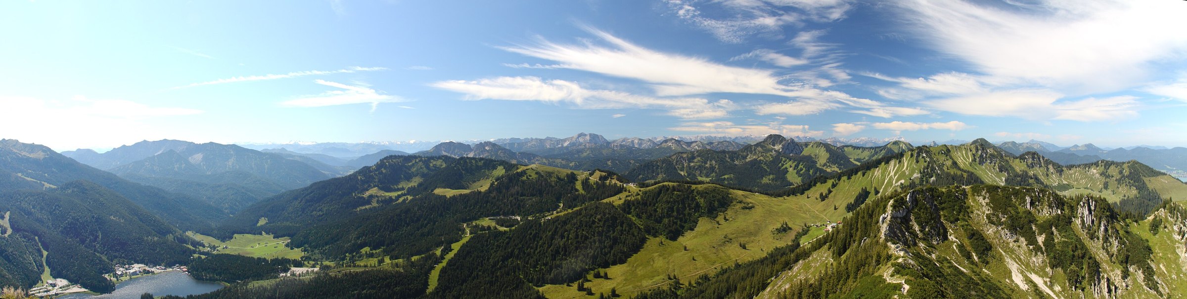
Spitzingsee and the surrounding mountains, viewed from Brecherspitz. Historical photograph taken on 11 August 2011.
OBERLAND / ARCHIVE2011-08-11 · Avarim
08 routesMap · Elevation profile · GPXBefore you go ↗

01 / Orientation

Explore the route map

Choose an area to frame the map, or select a route name to highlight its line.

HANG LAGE / OBERLAND

Loading the topographic map.

Routes and GPX downloads are available below.
↑ NColours show grade along the line, not difficulty or safety.

OpenStreetMap / Protomaps · Copernicus DEM · Routes retain individual sources and licences. Data sources & safety ↗

02 / Route portraits

8 routes by area

4 routes

Tegernsee & Risserkogel

Area on the map ↑

Broad forest roads and narrower mountain paths alternate on the slopes above Tegernsee. The Alpbachtal approach to Baumgartenschneid spends much of its ascent in woodland before views open over the lake and surrounding mountains. Neureuth and the hillside path reveal other parts of this landscape, while Setzberg and Risserkogel take the outings into higher mountain terrain.

02N ↑Route outline · no map scale

Tegernsee & Risserkogel · Hiking

Baumgartenschneid vom Alpbachtal

Baumgartenschneid vom Alpbachtal

The Alpbachtal ascent spends much of its climb in woodland. Broader tracks give way to narrower mountain paths before views open over Tegernsee from Baumgartenschneid.

Finish: Tegernsee, Prinzenweg im Alpbachtal

Mapped distance
11.5 km
Ascent from source
653 m
Time from source
5 h 00 min
Start, finish, difficulty & source

Source difficulty: 60 · BCT Schwierigkeit (0–100)

Baumgartenschneid vom Alpbachtal
BayernCloud Tourismus · CC0 1.0 · CC0 1.0

03N ↑Route outline · no map scale

Tegernsee & Risserkogel · Hiking

Tegernseer Höhenweg

Mit der Bahn in die Berge: Tegernseer Höhenweg

The high-level path links settlements by Tegernsee. Plan how to return from the stated finish.

Finish: Bahnhof Tegernsee

Mapped distance
5.8 km
Ascent from source
117 m
Time from source
1 h 30 min
Start, finish, difficulty & source

Source difficulty: 40 · BCT Schwierigkeit (0–100)

Mit der Bahn in die Berge: Tegernseer Höhenweg
BayernCloud Tourismus · CC0 1.0 · CC0 1.0

04N ↑Route outline · no map scale

Tegernsee & Risserkogel · Hiking

Setzberg und Risserkogel

Setzberg und Risserkogel

After the Wallberg cable-car ascent, the walk crosses Setzberg and Risserkogel before descending to the valley. Mountain paths, pasture meadows and rocky summit terrain shape the upper section. Include the cable car and subsequent descent in your plans.

Finish: Rottach-Egern Wallbergbahn

Mapped distance
17.2 km
Ascent from source
623 m
Time from source
6 h 15 min
Start, finish, difficulty & source

Source difficulty: 60 · BCT Schwierigkeit (0–100)

Setzberg und Risserkogel
BayernCloud Tourismus · CC0 1.0 · CC0 1.0

4 routes

Schliersee & Hausham

Area on the map ↑

Woodland ascents, Kreuzbergalm, Gindelalmschneid and Neureuth lie between Schliersee and Tegernsee. Views shift from one lake to the other along the way. The selected Prinzenweg variant passes Gindelalmen. Like the connection from Hausham to Schliersee, it finishes in another town, making the return journey part of the plan.

05N ↑Route outline · no map scale

Schliersee & Hausham · Hiking

Über die Gindelalmen zur Baumgartenschneid

Über die Gindelalmen auf die Baumgartenschneid

Via Gindelalmen and Kreuzbergalm to Baumgartenschneid; the source gives Schliersee station as the finish. Plan your return from there.

Finish: Schliersee Bahnhof

Mapped distance
16.3 km
Ascent from source
894 m
Time from source
5 h 00 min
Start, finish, difficulty & source

Source difficulty: 60 · BCT Schwierigkeit (0–100)

Über die Gindelalmen auf die Baumgartenschneid
BayernCloud Tourismus · CC0 1.0 · CC0 1.0

06N ↑Route outline · no map scale

Schliersee & Hausham · Hiking

Prinzenweg: Schliersee–Tegernsee

Auf dem Prinzenweg vom Schliersee an den Tegernsee

Prinzenweg connects Schliersee and Tegernsee. Alongside its elevation profile, consider how you will get back from the finish.

Finish: Tegernsee

Mapped distance
14.1 km
Ascent from source
570 m
Time from source
4 h 30 min
Start, finish, difficulty & source

Source difficulty: 60 · BCT Schwierigkeit (0–100)

Auf dem Prinzenweg vom Schliersee an den Tegernsee
BayernCloud Tourismus · CC0 1.0 · CC0 1.0

07N ↑Route outline · no map scale

Schliersee & Hausham · Hiking

Hausham–Gindelalm–Schliersee

Mit der Bahn in die Berge: Hausham Gindlalm-Runde bis Schliersee

Finish: Bahnhof Schliersee

Mapped distance
14.0 km
Ascent from source
590 m
Time from source
4 h 30 min
Start, finish, difficulty & source

Source difficulty: 60 · BCT Schwierigkeit (0–100)

Mit der Bahn in die Berge: Hausham Gindlalm-Runde bis Schliersee
BayernCloud Tourismus · CC0 1.0 · CC0 1.0

08N ↑Route outline · no map scale

Schliersee & Hausham · Hiking

Tegernsee–Schliersee: alternative Verbindung

Mit der Bahn in die Berge: Von Tegernsee an den Schliersee – mal anders

This connection leads from Tegernsee to Fischhausen-Neuhaus station at the southern end of Schliersee. It has a different finish from Prinzenweg into Schliersee town, so plan your return from the station actually reached.

Finish: Bahnhof Fischhausen-Neuhaus

Mapped distance
15.0 km
Ascent from source
929 m
Time from source
5 h 45 min
Start, finish, difficulty & source

Source difficulty: 80 · BCT Schwierigkeit (0–100)

Mit der Bahn in die Berge: Von Tegernsee an den Schliersee – mal anders
BayernCloud Tourismus · CC0 1.0 · CC0 1.0

03 / Side by side

Compare distance and ascent

These are hiking routes. The supplied times belong to each outing and are not calculated running times. Check path conditions, weather, closures and mountain requirements before setting off. ≈ marks ascent estimated from the elevation model. — means no time supplied. Different difficulty scales are not converted.

Route & areaDistanceAscentTime from source
01Von Gmund zur NeureuthHiking · Tegernsee & Risserkogel10.0 km537 mSource3 h 30 min
02Baumgartenschneid vom AlpbachtalHiking · Tegernsee & Risserkogel11.5 km653 mSource5 h 00 min
03Tegernseer HöhenwegHiking · Tegernsee & Risserkogel5.8 km117 mSource1 h 30 min
04Setzberg und RisserkogelHiking · Tegernsee & Risserkogel17.2 km623 mSource6 h 15 min
05Über die Gindelalmen zur BaumgartenschneidHiking · Schliersee & Hausham16.3 km894 mSource5 h 00 min
06Prinzenweg: Schliersee–TegernseeHiking · Schliersee & Hausham14.1 km570 mSource4 h 30 min
07Hausham–Gindelalm–SchlierseeHiking · Schliersee & Hausham14.0 km590 mSource4 h 30 min
08Tegernsee–Schliersee: alternative VerbindungHiking · Schliersee & Hausham15.0 km929 mSource5 h 45 min

04 / Before you go

What to check
before setting out

01

Hike or run?

Choose the route for its paths and difficulty. Plan to walk technical, steep or exposed sections. A GPX file and a route name do not establish that every section is runnable.

Sources & safety ↗
02

Course and return journey

Check the original start, finish and direction. A line may show only an ascent or a connection. Plan the return journey, last connection and any lifts separately.

See the original routes ↗
03

Path, weather and local rules

Check current conditions and local information. Observe closures, wildlife rules and operating hours. A mapped path establishes neither current access nor a particular surface quality.

Regional information ↗
This overview is for orientation, not navigation or a declaration of safety. Independent planning, appropriate equipment and on-site assessment remain essential.

HANG LAGE

Route maps and recording
on your phone and watch.

Download your map and route before setting off. In Hanglage, you can use them without a connection and record your outing.

See app features ↗
Research, data & image rights ↗

Editorial research: 3 November 2026. Original selection and text by Hanglage, not a statistical ranking or current conditions assessment. Route facts, original classifications and GPX retain their linked sources and licences.

Photograph: File:Spitzingseepano.jpg · Avarim · CC BY-SA 3.0 · 2011-08-11. Historical photograph, resized and cropped in the layout. Not current conditions.

  1. Tegernsee · Trailrunning
  2. Baumgartenschneid durch das Alpbachtal · BayernCloud Tourismus
  3. Prinzenweg zwischen Schliersee und Tegernsee · Tourismusverband Tegernsee-Schliersee

Full data sources & safety notes ↗